After a stop for lunch, we went to the most remote site of the day. Caesarea Philippi was a brief, yet significant site in the Gospel accounts. This is Day 4, part 4.
The following map marks Caesarea Philippi. From the Sea of Galilee that appears in the lower left of the map, this site is roughly halfway to Damascus. We officially entered the Golan Heights, but only by a little bit. The prominent thing to see at this site is the opening of a cave in a cliff. As one sees on the map, this cliff is on the southern edge of a mountain range. Mount Hermon is the high point of this mountain range. That mountain is not inside of Israel's borders. Some people have claimed that mountain as the Mount of Transfiguration, which would require them to walk into the mountains for 6 days, rather than start heading to Jerusalem. We will visit the Mount of Transfiguration the next morning at the traditional site of Mount Tabor.
Aside from the cave, the waterways in the area stand out. There are many tiny waterfalls. There is runoff from the mountains and there are springs that come forth from the mountains to form the rivers in this area. This waterway emerges on this site, just barely beyond some of these photos. This forms one of the tributaries that meet up downstream to form the Jordan River. So this is a form of headwaters for that river.


Before focusing on the cliff face and everything at the base of it, it helps to visualize what used to be here. There were temples to false gods all over this site. The Temple of Pan was a site of drunken orgies and human sacrifice. There would be so much blood that people would see the blood in the waterways that spring forth from the mountain. So this was very much a place of death associated with a false god.
But there was also a monument to Caesar Augustus here. Augustus was a clever man. After his father died, he asked the Senate to declare his father "god". They never would have declared a living ruler as a god, but they figured there wouldn't be any harm in declaring a dead man as god. Upon the declaration, Augustus stepped people through the reasoning that if his father was god, then he was the son of god, and thus god himself! The Senate had made a serious error, and each Ceasar from Augustus onward would use that declaration to make themselves into a false god.
When Jesus asks Peter who others say he is, there's a response. And when he asks who you say he is, Peter responds. Peter says, "You are the Son of the Living God!" That distinction of "living" is significant. Unlike Augustus, whose monument is in their presence, Jesus is the Son of the Living God, rather than being like Augustus and being referred to as the son of a dead [false] god. In addition, this is a God associated with the living, rather than being like Pan being associated with the human sacrifices of people who would end up dead.
I took several photos of the site. Most of the photos include the main cave.


There were some ruins of the various temples on site.

Up and to the left of the main cave is a trail. It's referred to as the Loop Trail. There doesn't seem to be too much to see along the route. I didn't include most of the photos from that loop. You have to go up many steps, which you can tell by the photo off the edge. I am looking down at the main area where the tourists shops, parking lots, etc. are, and the treetops are roughly level with me in this next photo. I had to rush a bit, since I wasn't sure where the trail would lead. I didn't look at the map closely enough before deciding to go. I wasn't sure if it would go to the top of the cliff (it didn't), or just some shorter or longer loop. So I walked briskly, and I still had time to spare. The gift shop had a raised relief map of Israel that would have been interesting to buy, but I wasn't sure if I would see it later in the trip, nor was I eager to pack it for the trip home, since I think I had the smallest total luggage of everyone I knew on the trip.
We knew Lebanon was very nearby since we saw some protected areas. We were led to believe that if we didn't turn at this fence to get to the bathroom that we would end up in Lebanon. But it appears that it might just be a Lebanese restaurant. It looks like the border was a bit further.
These remaining photos were from the drive to this place. The hills and cliffs have some color to them.
I was surprised to see what a straight line of mountain ridges was nearby. This is not like most mountain ranges where there were lots of peaks here and there. This small ridge looks like the land just folded upward with an occasional divide to allow water out of the area.
Only now as I reflect on the water situation do I think about how that place that experienced so much death provided the waters that would flow into the Sea of Galilee via the Jordan River entering it from the north, and then flows through the next segment of the Jordan River that exits near the south of that sea, just to flow into the Dead Sea. The water brings life in between the endpoints, but there was death at the start, and the saltiness of the Dead Sea brought death to anything in it or near it.
 |
| Caesarea Philippi |
The following map marks Caesarea Philippi. From the Sea of Galilee that appears in the lower left of the map, this site is roughly halfway to Damascus. We officially entered the Golan Heights, but only by a little bit. The prominent thing to see at this site is the opening of a cave in a cliff. As one sees on the map, this cliff is on the southern edge of a mountain range. Mount Hermon is the high point of this mountain range. That mountain is not inside of Israel's borders. Some people have claimed that mountain as the Mount of Transfiguration, which would require them to walk into the mountains for 6 days, rather than start heading to Jerusalem. We will visit the Mount of Transfiguration the next morning at the traditional site of Mount Tabor.
 |
| Map of Caesarea Philippi Area |
Aside from the cave, the waterways in the area stand out. There are many tiny waterfalls. There is runoff from the mountains and there are springs that come forth from the mountains to form the rivers in this area. This waterway emerges on this site, just barely beyond some of these photos. This forms one of the tributaries that meet up downstream to form the Jordan River. So this is a form of headwaters for that river.


Before focusing on the cliff face and everything at the base of it, it helps to visualize what used to be here. There were temples to false gods all over this site. The Temple of Pan was a site of drunken orgies and human sacrifice. There would be so much blood that people would see the blood in the waterways that spring forth from the mountain. So this was very much a place of death associated with a false god.
But there was also a monument to Caesar Augustus here. Augustus was a clever man. After his father died, he asked the Senate to declare his father "god". They never would have declared a living ruler as a god, but they figured there wouldn't be any harm in declaring a dead man as god. Upon the declaration, Augustus stepped people through the reasoning that if his father was god, then he was the son of god, and thus god himself! The Senate had made a serious error, and each Ceasar from Augustus onward would use that declaration to make themselves into a false god.
When Jesus asks Peter who others say he is, there's a response. And when he asks who you say he is, Peter responds. Peter says, "You are the Son of the Living God!" That distinction of "living" is significant. Unlike Augustus, whose monument is in their presence, Jesus is the Son of the Living God, rather than being like Augustus and being referred to as the son of a dead [false] god. In addition, this is a God associated with the living, rather than being like Pan being associated with the human sacrifices of people who would end up dead.
 |
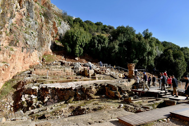
| Caesarea Philippi Historical Layout |
I took several photos of the site. Most of the photos include the main cave.


 |
| Near the main cave, looking to the right |
 |
| Up and to the left of the main cave looking down to the right of it |

 |
| Main Cave |


There were some ruins of the various temples on site.


Up and to the left of the main cave is a trail. It's referred to as the Loop Trail. There doesn't seem to be too much to see along the route. I didn't include most of the photos from that loop. You have to go up many steps, which you can tell by the photo off the edge. I am looking down at the main area where the tourists shops, parking lots, etc. are, and the treetops are roughly level with me in this next photo. I had to rush a bit, since I wasn't sure where the trail would lead. I didn't look at the map closely enough before deciding to go. I wasn't sure if it would go to the top of the cliff (it didn't), or just some shorter or longer loop. So I walked briskly, and I still had time to spare. The gift shop had a raised relief map of Israel that would have been interesting to buy, but I wasn't sure if I would see it later in the trip, nor was I eager to pack it for the trip home, since I think I had the smallest total luggage of everyone I knew on the trip.
 |
| View from the Loop Trail |
We knew Lebanon was very nearby since we saw some protected areas. We were led to believe that if we didn't turn at this fence to get to the bathroom that we would end up in Lebanon. But it appears that it might just be a Lebanese restaurant. It looks like the border was a bit further.
 |
| Lebanon Restaurant Anyone? |
These remaining photos were from the drive to this place. The hills and cliffs have some color to them.
 |
| Colorful Cliffs |
 |
| Snowcaps |
 |
| Ridge at the edge of the Golan Heights |
 |
| Ridge at the edge of the Golan Heights |
I was surprised to see what a straight line of mountain ridges was nearby. This is not like most mountain ranges where there were lots of peaks here and there. This small ridge looks like the land just folded upward with an occasional divide to allow water out of the area.
Only now as I reflect on the water situation do I think about how that place that experienced so much death provided the waters that would flow into the Sea of Galilee via the Jordan River entering it from the north, and then flows through the next segment of the Jordan River that exits near the south of that sea, just to flow into the Dead Sea. The water brings life in between the endpoints, but there was death at the start, and the saltiness of the Dead Sea brought death to anything in it or near it.
Comments
Post a Comment